Documents
Documents that you contribute are stored on this page. If you have anything of interest you want to share please contact me by email. Each document introduction will acknowledge its contributor. Links to your documents will be provided from the main site pages; for example, Place Names of Kinghorn (below) is accessed from Old Maps.
Place Names of Kinghorn
This document was researched and handwritten by Tom Fisher circa 1950. It was transcribed by Billy Ward (2014). See Billy's footnote.
Place names can sometimes give a clue to the character and history of the subject, or the area they represent. They often provide links over many centuries with their originators and although some of them have passed through innumerable variations of spelling, patient research has made it possible to arrive at their original form.
In Britain generally the language of the Celts, Anglo-Saxon and Scandinavians have helped to establish place names associated with these people. Scotland has place names that can be traced to the invaders of the Welsh–Celts infiltration, and to the Scots and Picts, and the invaders from Norway. In Fife, which was part of Southern Pictland, it is natural that place names of Pictish origin are predominant. The names that have come to us in Kinghorn and the surroundings are worthy of consideration. After studying a book on the Gaelic names of Scottish towns I found by breaking down some of the Gaelic words that they had a close resemblance to most of the names of the parish of Kinghorn.
- G. = Gaelic
- O.N. = Old Norse
- W. = Welsh
- M.E. = Medieval English (10th century)
- Sc. = Scots
- L. = Latin
Abden: This is the G. abaid "Land of the Abbey" — this was the seat of the Abthane, or over-thane, an ancient office in the days of the "Culdees" or Columban religious order.
Green Brae: This takes its name from the hill overlooking the Abden Cottage and Orchard.
Birrels Wynd: This may have derived its name from the material made in the mill at the bottom of the Wynd; the name of the material was called "Burel", a rough texture cloth. In Angus there is a town called Birrels Town that received its name from the same material.
Ladyburn Place: This roadway leading down to the Abden received its name from the burn that had its source in the North Myre, and also from the little spring that had the peculiar name of "Nell’s Hole".
Parsons Croft: This may have been the part of ground at the top of Ladyburn Place; on this piece of ground stood a very old sandstone building that was a common building material during the 15th and 16th centuries.
Trowes: This is the G. "troise", meaning "across the middle of the land" — this may be the real meaning of this pathway as it crossed the Mill Lands.
The Crafts or St Leonard's Lane: "Crafts" is the old Sc. word for "the field next to"; this may be the case as it was next to the mill lands.
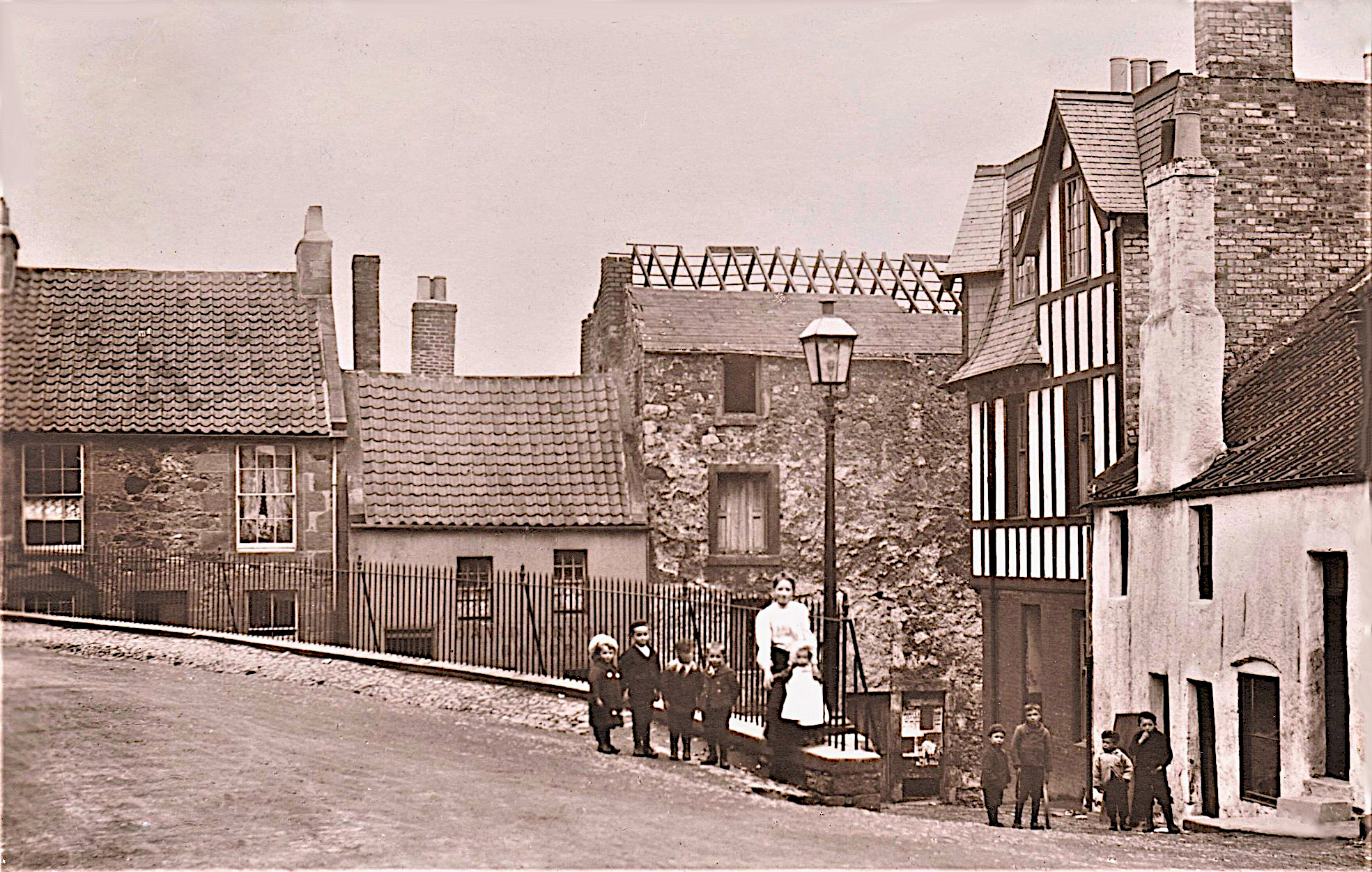
The Brig or St Leonard's Place: The Brig was a suitable name for this part of the town. Under the Turnpike Act of 1750 this part of the town was raised to the level of the High Street and the old draw well was covered up and a low wall was built that made a convenient seat for the old men of the town. Now these old houses have been demolished and a modern block of houses have taken their place, but this block of houses won’t have the charm or character of the old.
Cunzie Neuk: According to most of the historians of the Burgh they do not mention anything about a mint or the minting of coins. But according to enquiries being made by the daughter of Provost Smith, it was found that there is a record kept by the Guild of Goldsmiths of Edinburgh that in a corner of "Cunzie Neuk" there was a mint for the minting of coins.
Trongate: This was a gate leading to the Tron, or the weighing machine. The "Auld Hoose" postal address was 16 The Tron at one time.
The Tron: The place of the weighing machine and where goods were bought and sold.
Nethergate: This was the last road leading to the shore and ferry at one time.
St James Place: This was the part of ground situated at the corner of Nethergate and the "Gang". It takes its name from the Chapel and Hospital founded by Robert Pearson, one time a burgess of the town, who granted a piece of land for the support of a Chapel and Hospital, also for a chaplain for the Chapel of St James.
The Gang: This was the road facing the shore; the name "Gang" is the Sc. word for "go" or taken from the G. for the "toothless entrance".
Quarrel Brae: This part of the braes is supposed to get its name from a battle fought here between the Danes and the Scots, but it may be derived from Sc. quarry.
The Muckle Hole: This was a large hollow at the west end of the Braes that had been worn away by the water from the Leeches Loch (now "the cemetery") many centuries ago. At one time the town used this for dumping refuse; later they built a small esplanade to stop the sea from washing away the soil.
The Cave: This was a natural cavern in the side of the hill, but man had improved the entrance by hammer and chisel and by rounding the front of the cave.
The Harbour: Dates from early medieval times. For many years this was the main ferry between the South and the North, owing to the starting point of the old medieval track that joined up with one coming from Dunfermline to Falkland, also one going to St Andrews.
The Boat Neuk: This was the corner of the harbour situated at the Kirk Craigs where the fishermen laid their boats up during the winter months.
Barton Buildings: At one time this was the Old Harbour Mill that was converted into dwelling houses about the end of the 19th century. It received its name in honour of Sir Andrew Barton.
Salmon Cottage: These two cottages were at one time used as a fish curing yard, and at one time would supply Edinburgh with fresh salmon.
Carlin Head: M.E. and Old Norse. Kerling, old woman; so the name means the "old woman's head".
Parton Rocks: G. parton — "a little harbour", with rocks added would then mean "the harbour rocks".
Pettycur: C.1150 Petioker, 1277 – 1610 – etc. The name probably derives from Old Gaelic, meaning "croft of extortion" (high rented).
Old Inn and Hotel, Pettycur: At the beginning of the 19th century the old inn couldn’t cope with the great influx of travellers between Leith and Pettycur. At that time the stage-coach and ferry were run to a timetable.
The Salt Pans: The old salt pans were situated where the glass works now stand.
Wellhouse Spa: The Wellhouse Spa during the 17th century was a popular place for the gentry taking the water from this famous spa. Dr. Anderson the King’s Physician wrote a treatise on this water.
King’s Mid End: In a little field near the monument two stone cists or coffins were found; they belonged to the Beaker period and now lie in the Museum of Edinburgh.
The King’s Craig: This was the cliff that the King was supposed to have fallen over when making his way to Kinghorn Tower.
Grangehill: This is the Latin name for "church farm on the hill".
Slack Myre: This is the piece of ground that the farm buildings are built on; the name is derived from the Sc. word "slack" and "myre".
West Burn: This small stream divides the Rosslands from the Castleriggs; this stream made its way down by the old Tannery or the old Golf Club manufacturing business run by Mr William Gibson at the beginning of the 20th century.
Castleriggs: This piece of land was given to Murdoch Shank, an outlaw, who later received a free pardon and was given the land known as Castleriggs.
Kilcruik Lands: The land consisted of the field from the Candleworks to Barclay Road and Kilcruik Road to the old Tannery.
Kirk Steads: This was the land stretching from the Templers Walk to the Cross Road.
Gallow Plantain: This piece of ground was bought by the Burntisland Oil Company.
Candle Works: These works made candles and other articles from paraffin wax; many painters found work there in winter. The Burntisland Oil Co. closed the works after about ten years.
The Loch: This stretch of water was a source of energy for the many mills operating in the parish before the advent of steam. One of the oldest mills was Pease Mill.
Red Braes: Roadway leading to Kilrie; name may derive from the colour of the earth.
Cant’s Hill: The hillside stretching from the North Road to the Ghostan; also called Tammy Lowrie hill.
Banchory: This is the G. name for a "Sharp pointed hill".
Pitteadie: G. name for this Tower and farm is eadann-ain "a bit of land on the slope of the hill" or hill face.
Ketry: C1198, Kallori, G. eille Mhoire, the virgin Mary’s Church.
Chapel Flat: This was a small field on the way to Auchtertool; this may refer to the Chapel of Kilrie.
Glassmount: This is the G. for glas monaclh or "Grey Hill" or "mount". On one of the fields there stand two crude stones; they may be a monument to some warriors of the past, or they may represent some druidical temple that was replaced by the Christian faith, which took over the Culdee churches. This may be the case, for not far from here was the chapel of the Virgin "Mary’s".
Tyrie and Legmallee: The only remains of this mansion are the garden walls, with graceful corner strengths and well-built, and finely proportioned gateways. The present mansion house stands on the site of the old. In older days Tyrie could boast of a church that went under the name of "Ecclesia Sanctas Maria", now no longer to be seen. To this chapel from the Isle of May came St. Fillan to spend the rest of his days at the chapel of "Ecclesia Sanctas Maria". It is known that he died and was buried somewhere in the chapel grounds. The older people of the surrounding district found the high-sounding name difficult to pronounce, so they dubbed it Eggs Maline.
Seafield Tower: The present Tower was built on the site of a much older one. According to an old charter of 1309, King Robert I granted to William Kinghorn the lands of Seafield. The Moultray of Seafield came from Markinch in 1513, when John Moultray of Markinch and Kinghorn was killed at the battle of Flodden. We find traces of this contentious race in various pleas, complaints, and cautions. There were many traces of interchanging between the Moultrays and their neighbours. The family connection with Seafield ceased in 1626 when Robert Moultray sold the estate to Archbishop Law of Glasgow, who became the proprietor of the lands of Rescobie.
Vicar’s Grange and Old Vicar’s Grange: On the road leading to Seafield, Old Vicar’s Grange was on the right-hand side of the road, and Vicar’s Grange was on the left. This estate belonged to the reader of the Kirk of Kinghorn.
The Myres, North Mid, and Myres Park: These three fields were owned by the town and were let out to the highest bidders for grazing or for bleaching of material made in the mill of the burgh.
Bleaching Hill: This hill was a popular place for the bleaching of cloth by the people of the town, or by the mills for bleaching flax or linen.
Kilcruik Road: This is the name for a "cell or chapel in the woods". Robert Sibbald in his history of Fife gave Kinghorn the name of Kilgorn, meaning "the church on the green headland".
David Brown of Fordell, Finmount and Vicar’s Grange: His mother was Elisabeth Coutts of the Grange, daughter of Allen Coutts of the Grange. Vicar’s Grange was purchased from Sir George Erskine of Invertiel; the charter dates from 1630. David Brown died in 1643 and was succeeded by his sons David and John, and eventually by his daughter Christian. She married John Bruce of Wester Abden, a cadet of the Earlshall family, and with this union chose the surname of Brown with Vicar’s Grange. In 1638 David Brown added the lands of Wester Grass to his estate, described in the deeds of Sasine as lying in the parish of Kinghorn, between Vicar’s Grange and the sea on the south side of the stream running eastwards from the courtgate to the sea.
Grange: The name of this estate is taken from the Latin for "The Church Farm". This estate had many owners including the Sandilands and Coutts, but Kirkcaldy of Grange and the Hallyairds at Auchtertool were the most famous. During the invasion of Fife by the French, who arrived at the Hallyairds and found no one there, they set the place on fire and destroyed all the wall coverings and contents of the mansion. From there they travelled down to the Grange where they blew up the house with gunpowder. Kirkcaldy got revenge when he was informed that three French supply ships were in the harbour at Kinghorn; he descended on the harbour and put the crews of the ships to the sword, then set fire to the ships. The present building, baronial in style, shows a circular tower with the date 1687 and a monogram carved on the kitchen door. There is an entrance from the kitchen opening into a vault and underground passage leading, as some say, to Seafield Cave.
Bow Butts: This 16th century mansion stands on the site of an earlier building. Across the road from it was the Bow Butt farm and orchard, and their other field was situated at the Cross Roads, a small field on the right-hand side of the road leading to Craigencalt. Inside the grounds of Bow Butts at the corner of Eastgate and the Kirkcaldy Road stood a small pond fed from the water of the Lady Burn, but this was filled in by the owner at the beginning of the century; now the gardener’s house and garage have taken its place.
The Butts: Built onto the end of the orchard wall was another wall about ten to twelve feet high. This enclosure of ground was used for the practice of archery. On the side of Loch Road was a depression where there was a spring of fresh water; this spring would be welcome to the archers for quenching their thirst. This well had the peculiar name of "Nells Hole".
Templers Walk: This pathway dates back to Medieval times and may go back to the days when this was the starting point between the South and North. This track ran along the side of the orchard, across Loch Road and through a field belonging to Craigencalt, across a stile at Cants Hill (or Tammy Lowries Hill), from there to Banchory, then to Abbotshall and Chapel, Clunie, Dogton, then joining up with a track from Dunfermline at Kinglassie, then to Walkerton where it joined a track from West Wemyss, and finally to Falkland and St Andrews.
Barclay Road: This roadway was constructed at the beginning of the 19th century. It was named after the cottage at the top of the Gallowgate. One of the Barclays was town clerk for over 20 years. This roadway cut through part of the Glamis Castle Gardens that was on the opposite side of the Loch Burn.
The Cut or Castle Wynd: The opening through the hillside was made either in the latter half of the 18th century or the earlier part of the 19th century. This enabled the stagecoach an easier route to join up with the North Road. Previously, the old road had gone by High Street, Eastgate, Glamis Lane, up the side of Splash Mill (Hays Joiners Shop) to connect with the old Mid Road to Burntisland. The other road had gone by Eastgate, Gallowgate, joining up with North Road.
Baliol Road or Tannerie Toll House and Cottage: The old Toll House stood at the top of Castle Wynd and Baliol Road. Under the Tampots Act of 1750, road improvements were carried out, and roads in certain parts of the town were in place for the payment of tolls. The Toll House and cottage were demolished around 1930 to make way for modern housing.
Tannery: This work was situated where the Gibson Golf Club makers’ works stand today. A reference to the ship Cursour, with a cargo of hides, appeared in a cautan of 1599. There, the cargo of hides "now in a boat belonging to the Weemysous" shall be transferred from the St. Peter to the Cursour, but the cause of the transference does not transpire. The water for tanning came from the North Burn.
Leeches Loch and Witches Hill: During the building of the railway, a large part of the rocks were cut away. Leeches Loch was a dismal stretch of drained water. Later, the town sold it to the Parish Council for a new cemetery. At the top of the cemetery, at the part that the railway blasted away, was the part where the witch was burned; her name was "Katherine Wallenge", in the year 1667.
Pettycur: C1150. Petiocker, Old G. "pette cuir" "a bit of land at the turn or bend". Where the O is persistent, it may mean "croft of extortion". The harbour was, of old, a landing place for royalty, as the Royal Castle or Tower was built on the top of the hill overlooking the harbour. Many parts of this headland have been claimed for the siting of this tower, but the most feasible one is the one mentioned above, with the sea and hillside to the south and Leeches Loch to the west, and the lands known as the Jousting Lands to the north. This made a fine defensive place for his castle and tower.
Old Inn: The old Inn and stables were converted into houses after the ferry was transferred to Burntisland. At the height of the ferry, this old Inn would house many landed gentlemen and royalty before the hotel further up the road was built. At the end of the Inn stood a lean-to sort of house; this was a kiln for smoking fish or herring. Now the old house has been swept away, and a refreshment facility has taken its place. The basin across the road from the old inn and the old harbour master’s house, or superintendent’s house, was demolished and the material dumped into the basin. Now this is used as a car park.
Brick House: This house was built on a spur of rock at the ness. It was a handy landmark for fishermen; if you could see the Brick House and Seafield Tower in sight, you would sail clear of any rocks.
The Hotel: This hotel was built to accommodate the many travellers using the ferry. When the stagecoach was made to run to a timetable in conjunction with the ferry, this brought a greater influx of travellers. During stormy weather, most of the houses of the town were overflowing with travellers waiting to cross to Leith.
The Battery: This battery was constructed during the latter half of the 19th century, then at the beginning of the 20th century the government bought some acres of ground at the top of Crying Hill, where they constructed a few gun emplacements. After the 2nd World War, the High and Low Batteries were demolished and modern houses built on the ground that once, in conjunction with Inchkeith, held the key to the defence of the Forth.
Anne S. Swann’s House: This large freestone-built house was planned by the authoress Anne S. Swan as a holiday home for her husband and family. It was a retreat from the grime and dust and busy life of London. Annie S. Swan was one of the most prolific writers of her day; "The Peoples Friend", to which she contributed, was found in nearly every home. Her first home in Kinghorn was "Carlowrie", and then "Aldersyd", and from there to the Anchorage. After the tragic death of her son, she sold the Anchorage to local shipbuilder John Fletcher for £700, who later sold it to Gregor McGregor, head of the Fife Education Authority, for £1700. This is a little story about John Fletcher getting old Tommy Lawrence to paint the woodwork in some of the rooms of the house. After a few days, Fletcher paid old Tommy a visit. Looking into one of the rooms, he gave out a roar: "Hi Lawrence, were the watery waves coming into the bay?" Old Tommy asked, "Why, Mr Fletcher?" Fletcher’s reply was, "You have more waves on this woodwork than there are entering the bay."
The Port: This name means gateway. This was before the Burntisland Road was made, and the only road to the ferry was by Pettycur Road.
Glue Works: These works were situated where the Rosslands tea gardens now stand. They belonged to the Kinghorn family of Darneys. These works later closed down and were transferred to Edinburgh. Henry Darney gifted some fine oil paintings to the town that can be seen in the town hall today.
The School: This school has seen many additions added to its original octagonal dome that crowned the entrance hall and the museum, and the quaintly spired clock tower remains singularly attractive. With the coming of the railway, the Burgh bowling green and part of the school ground and buildings (1846), and at one time "Rose Cottage" with an entrance through a large pend, was used as an infant’s classroom (1872). Also, there was a small school held in the old mill at the harbour near Barton Buildings; these places were used until the infants’ classrooms were built beside the Burntisland Road.
Rossland Place: This part of the town contained many stables and a hotel. Bobby McNorgan had his stable facing the railway; the hotel was next to the church. Other stables were situated where the West End Café is now. These were the days when one could hire a horse and a man for 2d a mile; the charge for the man was for him to bring back the horse.
High Street: Before the Turnpike Act of 1750, the High Street was lower on the seaward side. With the Act of 1750, the High Street was raised to its present level. If you study some of the old houses on the seaward side of the street, you will see that they had to build retaining walls in front of some houses. Now these old houses are gradually disappearing, and the High Street is losing its homeliness; the modern brick houses will never acquire this character, nor mellow with age.
Gallowgate, Eastgate, North Overgate, and South Overgate: The word "gate" should be spelled "gaet". This is the old Sc. word for road and had nothing to do with gates. The old Sc. word for gates was Ports.
Pease Mill: Was situated on the lower side of the Trowes with the typical circular shape of the kiln rising above its desolate buildings. The entrance to this old mill was by an opening halfway down South Overgate. Over the old mill was the date 1751, an indication of rebuilding only, as the mill was one of Kinghorn’s earliest and most reliable assets of the burgh. A writ of 1614 shows that Patrick Kirkcaldie of Grange and Western Abden held the Jousting Lands along with Mclindins de Kinghorn, and some other properties. Edward II of England held the mill of Kinghorn for a while.
Bruce Street: This street received its name from Robert Bruce, who had married a granddaughter of Kirkcaldy of Grange, and as a marriage dowry, he received land known as Western Abden. His house stood at the top of South Overgate where the present Ship Tavern now stands. Robert’s brother, John Bruce, was eminent as a scholar, and became Professor of Logic at Edinburgh University. Eventually he held several important government appointments and did splendid services as an author, and in arranging the chaos of the state papers offices. Along with Sir John B. Blair he shared the reversion of the patent of Kings Printer for Scotland, which earned him the nickname "Bible Bruce." Thus, when T. Fisher built the Ship Tavern on the site of Bruce’s house, the saying became "from spiritual to spirits."
South Overgate: During the demolishing of the houses at South Overgate and Tron, some underground caverns were discovered. These would have been reservoirs for the mills, for starting up in the morning.
The Shipyard: This shipyard was started by a Kirkcaldy man who had a small shipyard at the bottom of Heggies Wynd at the Links. He later moved to Kinghorn. The next owner was the Scotts of Greenock, who faded in 1909. The yard was started up again by John Hatcher but did not last long, and ships were no longer built there.
Bellypuff: This may be the G. for baile, poor man’s house, or it may be belly for the farm near the village with puff added: Bellypuff.
Apple and Pear: These two holes in the rocks may have been made by erratic seas, or large pond stones that, through the ages, were shaped by the action of the sea, gradually forming these round holes in the rock.
Courting Rock: This was a favourite place for courting couples in days gone by, also for young women before the First World War, who passed away the time during summer months with their knitting or crocheting.
Hoch ma Toch and Burgh Boundary: This is the Gaelic for the Limestone Bay. At one time this had a large quantity of marine limestone. In the shale a little to the west of the little spring of water that runs down the rock, it was possible at one time to find the bones and teeth of carnivorous fishes of that period. The little stream that makes its way down from the railway to Lime Kiln, Beach and Rock and old Kiln: This part of the beach supplied, at one time, all of the lime required for building purposes. To this day you can follow the road from the beach as far as the Apple and the Pear. From there it follows where the railway had built the retaining wall that was washed away during a storm. The road then crossed over the tip of the Bellypuff, that before the shipyard made up the ground from the material taken from the shipyard, was extended when it came around the back of the Kirk.
A bit of Burntisland history: In 1654, a horse race was run annually on St. Peters day, from the East Port to Pettycur, instituted and continued until 1812. George Sanders, the miniaturist painter: George Sanders was born in Kinghorn in 1774. After an apprenticeship to a coach painter, he later was occupied principally in painting miniatures and teaching drawing. In 1807 he went to London and almost at once became the popular miniaturist of the day. Members of the Royal Household were amongst his sitters. From 1812 he turned his attentions almost entirely to painting life-size portraits in oil. In this branch of art his work was also in great demand. He died in London in 1846.
Kinghorn: In 1849 there were nine public houses and an inn at Pettycur. It seems the most popular were the "Lion", the "Three Crowns", and the "New Inn" at Pettycur. The town as a whole was turned into a place of entertainment as the passengers stayed by tide and storm. The town could also supply the travellers with saddled horses, as many as 60 were kept in the town. Now the ferry has disappeared, Pettycur has fallen into decay, and the public houses have been reduced to three, with two hotels.
The Curse of Kinghorn: This curse was laid on the town by an old woman who usually sat on a low wall above the steps leading down to Cunzie Neuk. It happened when the mill girls were making their way to the wishing well in the Doric Glen. One of the girls said to the old woman "Come Maggie, and wish you were young again." She replied, "Wish well for yourself, for the day will come when the work in the mill will prosper for a while and then fade."
Town Hall: This building was created in the Tudor style, and at one time was the most important building in the Burgh. It was designed by Hamilton of Edinburgh and erected at a cost of £2500, including the jail and the janitor's house. Nowadays this money would not buy a small bungalow. The Town Hall was built on the site of the old Tolbooth or St. Leonard's Tower, which was struck by lightning at the beginning of the 19th century. The present building was built in 1828.
Proverb of Kinghorn:
- Dysart for coal and saut
- Pathhead for meat and maut
- Kirkcaldy for lassies braw
- Kinghorn for breaking the law
Kinghorn for reasons which are not clear, was one of the poorest of the Royal Burghs of the East Coast and seemed to have a bad name in days of old.
- Kinghorn for cursing and swearing
- Burntisland for curing herring
As Burntisland no longer cures, it may be helped that Kinghorn no longer curses. How was this place better thought of than by the people? The fishes despised it long for its poverty in fish, and said of it: "Kinghorn bliss" (an enclosed bay): a muckle dish and little in it. Or as another person put it: "It's like Kinghorn, nae muckle worth."
Its better neighbours declared its sin in these lines: "Here stands a kirk without a steeple. A drunken priest and graveless people."
The passengers seemed to have fought shy of its ferry, for it was said: "Their many speir the road for Kinghorn sat kin it all the way to Pettycur."
Note a few genealogies and internments at Kinghorn: (Translated from Latin)
John Scodro: his son died at Kinghorn, and was buried there. John had three sons, namely Adam, John and Bert; Adam remained at Kinghorn, and after the coming of Baliol into Scotland, was slain in the Kirkyaird and was buried there. Genealogy of John son of Adam: "Adam, son of John Scordo elder, died at Kinghorn, and was buried there. John, his son, lives and remains there."
Genealogy of Brendin Paddying: "Seathune, son of Edward died at Pelkyochryir, and was buried at Kinghorn. John, the brewer, his son died in Pettycur, and is buried at Kinghorn. Malethy, his son died at Kaskybarren, and is buried at Kinghorn."
Genealogy of the son of John Malethy: Malethy son of Gilgrewed, the fore said, died at Gathmilk and is buried at Kinghorn.
Ecclesiastical Notices: There seems little information of the two churches of Easter and Wester Kinghorn. Prior to the Reformation (1502), a document at Dunfermline stated that this would be known as Wester Kinghorn to distinguish it from the one in Kinghorn, called at that time Kinghorn Easter. The former (Kinghorn) was the name of the Parish but the ancient name of the town was Barterland or Burtiland. In the printed "Requintrum de Dunfermline" there are three deeds by the Bishop of St. Andrews, two in the 12th century and one in the 13th century, confirming the grants of the church of Kinghorn Wester to the Abbey of Dunfermline. In a taxation of the 13th century, there are the following entries: The Kirk of Kinghorn paroa (small) to be valued at 100 shillings, that of Kinghorn magne (great) is valued at £X.merks (£45-6-8 Scot.). Those values would accrue to the Abbey of Dunfermline, to which these churches belonged, by gifts of the Bishops.
Local Medieval Tracks: The Broad ferry, as the ferry between Leith and Kinghorn was named, was the most popular of all the ferries of the Forth between the South and the North, for it was the starting point for an old medieval track that joined up with a track coming from Dunfermline to Falkland, also one going to St. Andrews, often used by Archbishop Beaton and Sharp. These old tracks were used long before the Romans came to Britain. It seems probable that some of the tracks formed by the prehistoric people of Fife were also used by our Pictish ancestors. A tribe of the latter, the Horesttic, occupied this part of Scotland when the Romans were here, and no doubt such tracks aided the latter to penetrate well into Fife and also to the shores of the Tay.
St. Fillan: From the Island of May, as far as history is traceable, came the priory of Pet-Wymess, "The settlement in the caves". It is associated in its earliest day with St. Priscan, and here lived St. Fillan of Fife, who has been almost inextricably confused with two other Saints of the same name: St. Fillan called the "Leper" through misreading, and St. Fillan of Galloway and Strathclyde. St. Fillan rose to be Abbot of Pittenweem. It is at least known with certainty where he died, for it is recorded that in his old age he retired to "Disent" of Tyrus where he passed away. "Tyrus" is Tyrie, situated in the valley behind Kinghorn. It may be that his dust lies in the obliterated church yard at Legmaline on the land of Tyrie. This place was named in 1169 as Ecclessmalee or the church of St. Maline, the same name which appears in the name of the famous Belgian city.
Johny Stocks, the dwarf who followed Patie Birnie: O Johny Stocks, what comes of thee? I’m sure that it breaks thy heart and dee. Thy Birnie’s gone, there’ll never be her blithe, nor able to spook thy short laughs merrily upon the table.
The fiddler followed the Kinghorn Regiment to the battle of Bothwell Bridge. At Bothwell Brig he went to fight, but being wise as he was wight, he thought it showed a soul but slight. Darthy is starid and let the gunpowder wrang his site, or fiddler’s hand right pawkely he left the plain, nor over his shoulder looked again, but couried over moss and muir amain, and to Auld Reekie straight, and told how many were slain before they fought.
The effigy of Pattie Birnie, famous fiddler of Kinghorn: Wha gants the leiges gaff and girn aft till the cock from lain the morn? The path, his wads, and mirth were pernie. He roo’d these things were langest worn. The large ale barrel way his kirn aye, and faithfully he temed his horn.
Footnote by Billy Ward: I believe I got most of it as it was written; maybe a few words towards the end are not quite correct, but they can be changed if necessary.
I found this very interesting indeed, and I certainly learned a lot about the "Place names of Kinghorn". One in particular was Birrels Wynd where I grew up and lived for 21 years; I now know where the name came from and why Birrels only has one "L". My teachers always accused me of spelling it incorrectly.
So thanks to Tom Fisher for handwriting this, no easy task in his day.
Who was Tom Fisher? We know, after reading this, that T. Fisher built the Ship Tavern, probably early 20th century. Mrs Tulloch I knew was born in the ship in 1912, so after speaking to Charlie I found out that Mrs Tulloch’s mother was a Fisher, so we thought that T. Fisher would have been her grandfather or uncle. No doubt more information will unfold on this one.
When did he write this? He mentions a couple of things that relate to the time he wrote this, namely: West End Café was operating then, he mentioned the Rosslands Tea Gardens, then there was W. Gibson Golf Club Makers (The Cleek Works). Gibsons closed in 1955, so that is the latest date that it could have been; the other two went on a bit longer than that. He also mentions the Second World War, so that would make it, in my opinion, between 1945 and 1955.
Kinghorn Bottleworks
Around 1901 Wm. Bailey (Mid-Lothian Glass Works, Portobello) built a bottle manufacturing plant on the site of an old Saltworks at Pettycur Bay. It was closed about a year later. The factory was then re-opened in 1908 by the Kinghorn Bottle Co.
In 1937 the Kinghorn Bottle Co. was taken over by United Glass. They owned ten glass factories, numbered from 0 to 9:
- 0 = Harlow
- 1 = New Cross
- 2 = Sherdley
- 3 = Ravenhead
- 4 = Castleford
- 5 = Shettleston
- 6 = Brimsdown
- 7 = Kinghorn
- 8 = Alloa
- 9 = Peasley
The factory number was used to identify their products, for example UG 7 for Kinghorn.
The Kinghorn furnace was rebuilt at a cost of one million pounds in 1980. The following year, United Glass announced that it would be closing the factory in April 1982 with the loss of 145 jobs.
Read the newspaper story announcing the closure.
Harry Julian by Billy Ward
My only memory of Mr Julian was when I went to Kinghorn Primary School for the first time in August 1940. He was Headmaster then. I was standing at the front gate, probably wondering what to do when he came along and picked me up, put me on his shoulders and carried me up to the Infant School. He left the school not long after that to take up another position within the education system. The other memory I have of him was when I joined the scouts in 1947 and for the next six years I went to the Scout Hall (Julian Memorial Hall) every Friday night where there was a painting of Harry Julian hanging on the wall with the words “Big Chief” written at the bottom.
Here are some of the records that I picked up from Scout Records and books about Kinghorn.
Harry Julian was the founder of Kinghorn Scouts and also a contemporary with Baden Powell (founder of the Boy Scouts). He visited Sweden and Hungary with the scouts. Kinghorn had special connections with Baden Powell, and Harry Julian was on the first ever special training course called “the Wood Badge Course”, run by Baden Powell. Jim Basham was on the first ever wood badge course to be held in Scotland.
Mr Harry Julian came to Kinghorn from Plymouth to become a member of staff at Kinghorn Primary School in 1907. Kinghorn Scouts were formed in 1910. When the First World War broke out in 1914, Harry Julian joined the Royal Scots and took part in the Battle of the Somme in which he was wounded. In the latter part of the War, he served in Mesopotamia.
On demobilisation in 1919, with the rank of Major, he returned to Kinghorn School as Headmaster. He became very much involved in the Scout Movement and had responsible positions in jamborees held at Wembley, Birkenhead, Hungary, Sweden and Holland. He was awarded the highest Scout decoration the “Silver Wolf”, by Lord Baden Powell. When the Second World War started in 1939, he was put in charge of Air Raid precautions for the district and worked tirelessly for the safety of the local community. He died in 1943. As a token of appreciation for his work on behalf of the Scouts and the people of Kinghorn the Scout Hall was to be named the Julian Memorial Hall.
Daisy Fields by Nellie Phillips
- I wandered out on a summer’s day
- Towards the Easter Braes
- The cheerful guard at the station
- Stopped me on my way
- “Where are you off to this bright morn?”
- Said he with a friendly smile
- “I’m off to walk to the daisy beds
- An hour to beguile”
- So with a laugh he waves me on
- And I stroll to the Belly Puff
- To find it almost full to the top
- With waves most high and rough
- The Apple and Pear I saw on the rock
- And the mark of a Cloven Hoof
- I thought I was in enchanted land
- With the sky above my roof
- The curlew called and the seagulls fed
- And the wee flowers smiled at me
- Then when I reached the Daisy Beds
- I heard the honey bee
- ‘Twas there I looked in a mirror pool
- Where crabs and starfish abound
- Where the seaweed waved and mussels clung
- With anemones bright around
- On the beach I found a fossil old
- Pebbles shiny and bright
- And, oh, I thought them jewels of gold
- To fill me with delight
- So if you have some time to spare
- And wish to be like me
- Then take a walk to the Daisy Beds
- And see all that I could see